


MOVE-ME.AMP

Beschreibung von MOVE-ME.AMP
** MOVE-ME.AMP ONLY WORKS IN OPORTO CITY **
MOVE-ME.AMP is a prototype of an application that allows mobile access to global and diversified information about public transports available in Oporto city.
Fully new in Portugal, MOVE-ME.AMP shares to the final user wide and spread information concerning several operators of public transports and allows planning our routes in real time with features like intermodality and real time.
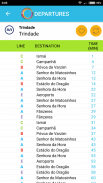
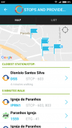
Nevertheless, the system allows finding the next departures, consulting the waiting times and destinations that are associated to next vehicles of a place chosen by the user.
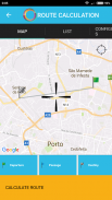
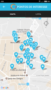
An integration of maps enables the user to define a localization providing information such as:
• What are the nearest stops?
• What are the nearest points of interest?
• When is the next vehicle to pass in this stop?
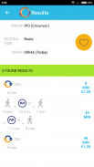
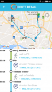
The route finder helps the user to find the best route to a specific place. The places can be bus stops, metro and train stations, points of interest and GPS localizations. The solutions given take into consideration the real time vehicle positions and return the best option for that moment. The system informs the passing time for each stop, the local place to change and walking route between them.
** MOVE-ME.AMP funktioniert nur in Oporto CITY **
MOVE-ME.AMP ist ein Prototyp einer Anwendung, die den mobilen Zugriff auf globale und diversifizierte Informationen über die öffentlichen Verkehrsmittel in der Stadt Porto ermöglicht.
Völlig neu in Portugal, MOVE-ME.AMP Aktien an den Endverbraucher breit und Verbreitung von Informationen mehrere Betreiber von öffentlichen Verkehrsmitteln über und ermöglicht mit Funktionen wie Intermodalität und Echtzeit in Echtzeit unsere Routen planen.
Dennoch erlaubt das System die nächsten Abfahrten zu finden, die Anhörung der Wartezeiten und Ziele, die durch den Benutzer ausgewählt, um neben Fahrzeugen von einem Ort verbunden sind.
Eine Integration von Karten ermöglicht es dem Benutzer, eine Lokalisierung der Bereitstellung von Informationen, wie beispielsweise zu definieren:
• Was sind die nächsten Stationen?
• Was sind die nächsten Punkte von Interesse?
• Wann ist das nächste Fahrzeug in dieser Haltestelle bestehen?
Die Route Finder hilft dem Anwender, den besten Weg zu einem bestimmten Ort zu finden. Die Plätze können Bushaltestellen, U-Bahn und Bahnhöfe, Sehenswürdigkeiten und GPS-Lokalisierungen sein. Die Lösungen gegeben berücksichtigen die Echtzeit-Fahrzeugpositionen und geben die beste Option für diesen Moment. Das System informiert die Durchlaufzeit für jeden Anschlag, der lokalen Ort zu ändern und Wanderweg zwischen ihnen.
MOVE-ME.AMP – Version 2.2.17
(01-02-2020)
MOVE-ME.AMP – APK Informationen
APK Version: 2.2.17Paket: com.movemeNeueste Version von MOVE-ME.AMP
Weitere Versionen


 4.35
4.35


Apps in derselben Kategorie

Das könnte dir auch gefallen...


